


Storm & Flood Preparedness
Storm & Flood Preparedness

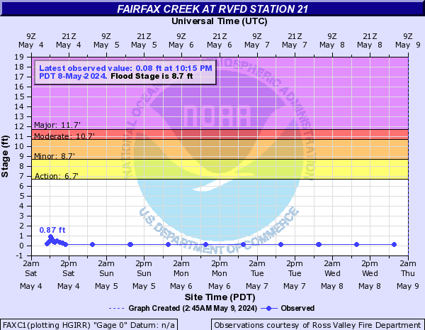
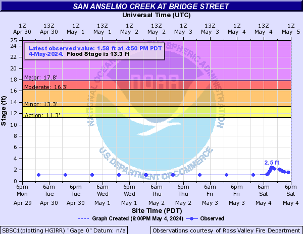
Creek Levels and Weather
Monitor RVFD's Creek Level and Weather information
Flood Preparedness
Protect People and Property:
Know Your Flood Hazard:
Build Responsibly:
Learn More About Local Flood Control:
- San Anselmo Flood Committee
- Marin County Public Works Flood Control District
- Letter to Morningside neighbors regarding flood mitigation planning
Please do not leave piles of leaves in the roadway. Please rake them up and place them in your green bin for disposal. Leaves left in the street will block storm drains and may lead to flooding.
More information on high tides and flooding can be found here.
Storm Preparedness
Power Outages
PG&E Provides a "real-time" online map showing known power outages in your area.
- http://www.pge.com/outagemap/
- Click on a marker to see more information, such as number of customers affected and estimated time to restore power.
- Never approach downed power lines. Do not attempt to move downed lines of any kind. Never attempt to step over downed lines. Move away and report the downed lines by dialing 9-1-1.
- Have flashlights and battery-operated radios with fresh batteries ready for updates on storm conditions and power outages. Tune in to KQED 88.5 FM, KCBS 740 AM or KGO 810 AM.
- Fire Officials recommend that residents do not use candles because of the risk of fire. Use battery-powered light sources.
- Anticipate power outages prior to the storm, and bookmark PG&E’s power outage page.
- PG&E 1.800.743.5002
Downed Trees and Limbs
- If the tree is on private property or has fallen onto private property contact the property owner.
- If the tree is touching electrical wires contact PG&E at 800-743-500 or non-emergency dispatch at 415-442-4526.
- If the tree or limb is causing an immediate danger, call 911 from any land or mobile phone.
- If the tree or limb is blocking a public right of way or roadway, contact your local Department of Public Works.
Drive with Caution
- When driving in the rain, use extra caution and always have your headlights on. Remember, if you turn on your windshield wipers, turn on your headlights.
- Please obey the speed limits and follow other traffic at a safe distance.
- Do not drive through standing water. Only 6 inches of water can be enough to stall your car and cause irreparable damage to the engine.
- Please anticipate road closures and traffic back-ups due to flooding, downed trees or landslides. Check traffic conditions before you hit the road.
Landslides
If you live in a landslide prone area consider hiring a geologist that specializes in slide risk assessment to complete a ground study of your property. Learn to recognize potential landslide warning signs:
- Changes occur in your landscape such as patterns of storm-water drainage on slopes
- Water breaks through the ground surface in new locations
- Bulging ground appears at the base of a slope
- New cracks appear in plaster, tile, brick, or foundations
- Fences, retaining walls, utility poles and trees tilt or move
- Collapsed pavement, mud or fallen rock along roadways
How can you minimize your landslide risks?
- Regularly inspect your property for land movement, retaining wall failures and blocked drainage routes
- Meet with your neighbors to discuss and repair mutual drainage problems
- Prepare an escape route in case you need to evacuate your home because of a slide above or below you
If you discover any earth movement or landslide, immediately leave the area and notify neighbors and emergency services by dialing 911.
Create/Check Your Emergency Kit
A disaster supplies kit is simply a collection of basic items your household may need in the event of an emergency. Visity ready.gov for resources on building an emergency kit.
Businesses
How quickly your company can get back to business after an emergency often depends on planning done today. Ross Valley Fire Department encourages all business owners to start planning now to improve the likelihood that your company will survive and recover.
- Develop a continuity of operations plan. Carefully assess how your company functions to determine which staff materials, procedures and equipment are necessary to keep the business operating.
- Review emergency communications with staff. Set up a telephone calling tree or email alert to communicate with employees, designate an out-of-town phone number for employees to call, give employees wallet-cards with important phone numbers.
- Review how to decide to stay or go. Have an Evacuation Plan and a Shelter-In-Place Plan.
Stay Informed
In an emergency, communication is crucial to the safety of all residents and businesses. Please bookmark or sign up for the communications methods listed below:
- We will provide updates about the storm as needed on our website.
- Sign up for Alert Marin to receive notifications on your devices and phone! Emergency officials use Alert Marin to deliver incident-specific information or potentially life-saving instruction to the precise geographic area(s) affected.
- Sign up for Nextdoor - a private, neighborhood-based social network.
- Nixle will send alerts to your mobile phone or email.
- Tune in to KQED 88.5 FM, KCBS 740 AM or KGO 810 AM and local TV stations for further information
When to call 911
- In an emergency, call 911 immediately from any wired or wireless phone. An emergency is any situation that requires immediate assistance from the police, fire department or ambulance such as a fire, a car crash (especially if someone is injured), or a medical emergency where a person is requiring immediate medical attention.
- If you hear the Town's Emergency Siren, do not call 911. Instead, look for immediate danger, move to high ground if you are in a flood zone, and tune in to KQED 88.5 FM, KCBS 740 AM or KGO 810 AM and local TV stations for further information.
Watch/Warning Terminology
- Flood Watch: Issued whenever flooding is considered a possibility (but is not certain or imminent)
- Flood Warning: Issued to warn the public that flooding is occurring or is imminent.
- Flash Flood Watch: Indicates that flash flooding is a possibility in or close to watch area.
- Flash Flood Warning: Signifies a dangerous situation where rapid flooding of small streams or urban areas is imminent or is occurring.
- Urban and/or Small Stream Flood Advisory: Alerts the public to flooding which is generally only an inconvenience (not life threatening) to those living in affected areas.